
🌍 Earthquake Vulnerability Map of India – New Data (2025 Update)
What needs attention
- The article topic must be linked to the actual occupancy and hazard
- Prevention and early warning provide more safety margin than last-second intervention
- Equipment is effective only when correctly selected, accessible and maintained
- People need short practised actions and a clear decision to stop and escape
- Children, visitors and people needing assistance require explicit planning
- Records, drills and inspections matter only when defects are corrected
Controls that reduce risk
- Complete a task- and site-specific hazard assessment
- Verify applicable Indian, state and local requirements
- Use competent inspection for installed systems and specialist hazards
- Keep alarms, exits, signs and emergency access usable
- Train intended users and practise evacuation
- Record defects with an owner and completion date
- Review the plan after changes, incidents or near misses
Understand and apply the guidance
🔴 Truth Drop
India experiences an average of 2–3 significant earthquakes every year, but most citizens remain unaware that nearly 59% of India’s landmass is vulnerable to moderate or severe seismic activity.
(Source: NDMA, Geological Survey of India, IMD Seismology Division 2025)
👉 Over 250 earthquakes of magnitude 4.0+ were recorded between 2020 and 2025, with tremors felt across Delhi, Northeast India, and the Himalayan belt.
India isn’t earthquake-free — it’s underprepared.
📖 Why This Matters
Every major Indian city — from Delhi to Guwahati, Srinagar to Dehradun, Patna to Gangtok — lies in or near seismic zones IV or V (high risk).
Yet, most residential buildings, schools, and hospitals are not earthquake-resistant.
When disaster strikes, it’s not the earthquake that kills — it’s the building collapse, the panic, and the lack of preparedness.
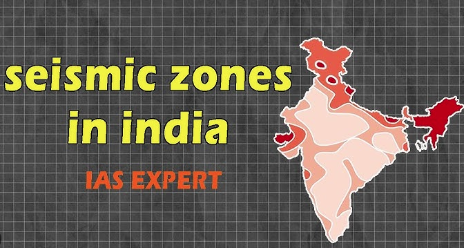
🗺️ India’s Earthquake Hazard Zonation (as per 2025 GSI/NDMA Data)
| Zone | Seismic Intensity | % of Land Area | States / Regions Covered | Major Cities at Risk |
|---|---|---|---|---|
| Zone V (Very High Risk) | Magnitude ≥ 8.0 | 11% | Entire Northeast, parts of J&K, Himachal, Uttarakhand, Bihar, North Andaman | Guwahati, Imphal, Aizawl, Gangtok, Srinagar |
| Zone IV (High Risk) | Magnitude 7.0–8.0 | 18% | Delhi NCR, North Bihar, Sikkim, Himachal, parts of Gujarat | Delhi, Patna, Shimla, Dehradun |
| Zone III (Moderate Risk) | Magnitude 6.0–7.0 | 30% | Maharashtra, MP, Chhattisgarh, Odisha, Telangana | Mumbai, Nagpur, Raipur, Bhubaneswar |
| Zone II (Low Risk) | Magnitude ≤ 6.0 | 41% | Peninsular India, Tamil Nadu, Kerala, Karnataka | Chennai, Bengaluru, Hyderabad, Pune |
(Source: NDMA & GSI Earthquake Hazard Zonation Map 2025 Update)
📊 Data Highlights (2019–2025)
- Total Earthquakes Recorded (Magnitude ≥ 4.0): 257
- Strongest Quakes:
- Sikkim (2021): 6.1 magnitude
- Arunachal (2023): 6.4 magnitude
- J&K (2024): 5.9 magnitude
- Delhi-NCR (2025): 5.4 magnitude (no major damage, but panic in 5 states)
- Lives Lost (2019–2025): 1,850+
- Economic Loss (approx.): ₹18,000 crore
- High-Rise Building Damage Risk: 1 in 5 structures in Zone IV & V non-compliant with seismic safety codes.
🧠 Why Earthquake Risk Is Rising
- Rapid Urbanization Without Safety Codes – 90% of new buildings lack seismic design compliance.
- Population Density – More people, more collapse risk in cities like Delhi & Guwahati.
- Plate Tectonic Movement – Indo-Eurasian plate continues to push north at ~5 cm/year, building Himalayan stress.
- Ignored Early Warnings – Poor coordination between IMD, NDMA, and local authorities.
- Lack of Citizen Preparedness – No drills, no evacuation knowledge.
🗺️ Visual Infographic Idea
Title: “India’s Earthquake Risk Zones (2025)”
- Red Zone (V): NE states, J&K, Himachal, Uttarakhand
- Orange Zone (IV): Delhi, Bihar, Sikkim, Gujarat
- Yellow Zone (III): Central India
- Green Zone (II): Southern India
➡️ Include population density overlay to show urban exposure risk.
🛡 Survival Lessons for Citizens
✅ Before an Earthquake:
- Know your seismic zone — check NDMA maps online.
- Identify safe zones: under sturdy tables, against inner walls.
- Prepare a 72-hour emergency kit (torch, food, first aid, radio, water).
- Secure heavy furniture and wall hangings.
✅ During an Earthquake:
- Drop, Cover, Hold On.
- Stay away from windows, lifts, and power lines.
- If outside, move to an open ground.
- If driving, stop safely and stay inside vehicle.
✅ After an Earthquake:
- Do not rush into damaged buildings.
- Turn off gas and electricity.
- Help injured neighbors — avoid panic rumors.
📢 Systemic Lessons
India must:
- Enforce Bureau of Indian Standards (IS 1893, IS 13920) in all new constructions.
- Retrofit schools, hospitals, and heritage buildings in Zones IV & V.
- Establish real-time seismic alert systems integrated with Bharat 101 or NDMA apps.
- Conduct quarterly public drills across high-risk districts.
- Train VFF India–style community volunteers in basic search & rescue.
📣 Call to Action
🚨 Earthquakes can’t be predicted — but survival can be prepared.
👉 Know your zone. Secure your home. Join your local awareness drive.
Preparedness isn’t panic — it’s protection.
📎 References
- National Disaster Management Authority (NDMA) Earthquake Guidelines, 2025
- Geological Survey of India (GSI) Seismic Zonation Atlas, 2025
- India Meteorological Department (IMD) Seismology Data Report, 2024
- UNDRR Asia-Pacific Earthquake Risk Outlook, 2023
- Bureau of Indian Standards (IS 1893:2023 Revision)
🔚 Closing Line
Earthquakes don’t kill — unsafe structures and unprepared people do.
This is why we built HowToSurvive.in — to make every citizen aware, ready, and resilient before the next tremor strikes.
Common unsafe practices
- Relying on equipment without a hazard assessment
- Blocking or compromising escape routes
- Delaying the alarm or emergency call
- Attempting a response beyond training or safe conditions
- Re-entering before authorised clearance
- Treating a checklist as a substitute for competent inspection