
Case Study
What happened here
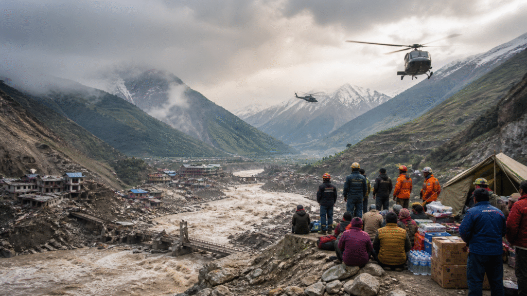
HazardMixed rock, ice, mud, water and debris moving through confined valleys.
Warning timeExtremely compressed in downstream communities.
Access problemRoads, bridges and communications were destroyed or blocked.
Current record1,403 recovered bodies and 6,150 missing in Nepal, dated 17 September; not a final cross-border total.
Immediate survival principleMove uphill and away from the river channel without waiting to watch the surge.
A rock-and-ice collapse high in the Himalayas became a fast, channelled debris-flood cascade across the Nepal–Tibet border. Three weeks later, Nepal's disaster authority figures relayed by AP recorded 1,403 recovered bodies and 6,150 people still missing, while access, identification and family tracing continued.
Nepal–Tibet Flash Flood: 800+ Dead and the Mountain-Flood Survival Lessons
**HowToSurvive.in | Know Before You Need to Know**
## 📅 Date & Location
– **Initial disaster:** 26 August 2026
– **Area:** Himalayan river valleys across northern Nepal and Tibet’s Gyirong region near the Nepal–China border
– **Hazards:** Glacier/bedrock collapse, temporary debris blockage, sudden flood surge, mudslides and continuing secondary-flood risk
– **Reported impact by 30–31 August:** At least about 800 deaths and more than 3,000 missing across Nepal and Tibet in major international reporting
## 🕯️ What Happened?
A huge mass involving glacier ice and underlying rock collapsed high in the Himalayas. Preliminary scientific analysis indicates that debris temporarily blocked river flow before releasing a catastrophic surge of water, mud, ice and rock through downstream valleys.
Flood levels reportedly rose with extraordinary speed. Settlements, roads, bridges and border infrastructure were overwhelmed. Rescue access was restricted by destroyed highways, unstable slopes, debris and the possibility of additional flooding.
Nepal’s government said all available resources were being mobilised for search, rescue, relief and recovery, including efforts to locate missing Nepali and foreign nationals. International reports placed the combined death toll at around or above 800, with more than 3,000 people missing. These numbers must remain dated because identification and search operations were continuing.
## 📊 Incident Snapshot
| Item | Reported status |
| Date | 26 August 2026 |
| Trigger | Preliminary analysis: glacier and bedrock collapse with temporary river blockage and sudden release |
| Deaths | Approximately 800+ across Nepal and Tibet in reports reviewed |
| Missing | More than 3,000 reported |
| Main effects | Flash flood, debris flow, landslides, destroyed settlements and infrastructure |
| Rescue barriers | Blocked roads, unstable terrain, damaged bridges, secondary-flood risk |
| Official response | Search, rescue, evacuation, relief and international coordination |
## ⏱️ Timeline
**26 August** — Ice and rock collapsed high in the Himalayan region. A massive flood/debris surge travelled downstream into populated valleys.
**First hours** — Settlements and infrastructure were buried or swept away. Communications and road access failed in heavily affected areas.
**27–29 August** — Helicopter and ground rescues expanded where weather and terrain allowed. Scientists examined satellite imagery to understand the initiating collapse.
**30 August** — Nepal warned of possible fresh flooding, sent phone alerts and continued efforts to reopen critical access routes. Official briefings prioritised missing people, survivors and foreign nationals.
**31 August** — Identification, recovery and relief continued. Published casualty figures remained provisional.
## ✅ Confirmed Facts vs ⚠️ Preliminary Interpretation
### Confirmed or strongly supported
– A catastrophic cross-border flood and debris-flow disaster began on 26 August.
– Hundreds died and thousands were reported missing.
– Settlements, roads and bridges suffered extensive destruction.
– Nepal mobilised national search, rescue and relief resources.
– Continued river and slope instability complicated operations.
### Preliminary or evolving
– The exact physical sequence of glacier, bedrock and temporary-dam failure.
– The final number of deaths, missing people and affected foreign nationals.
– The full contribution of long-term warming to this particular collapse.
– Whether every reported secondary surge came from the same mechanism.
Scientists have linked Himalayan warming to increasing glacier instability generally, but responsible reporting must distinguish that broader risk from the final attribution of one event.
## 🔍 Why the Disaster Became So Deadly
### 1. Extreme warning-time compression
A sudden high-mountain release can reach downstream communities faster than conventional flood forecasts can provide useful warning.
### 2. Dense debris, not water alone
Mud, boulders, ice and building debris increase destructive force. A flow may behave more like moving concrete than an ordinary river flood.
### 3. Valley confinement
Steep valleys channel flow, leaving limited lateral escape routes. Roads and settlements often occupy the same narrow corridor as the river.
### 4. Cascading infrastructure failure
Destroyed bridges and roads prevent evacuation, delay rescue and isolate hospitals, shelters and communities.
### 5. Continuing secondary hazards
Debris can create new temporary dams. These may fail later, while landslides and unstable banks threaten responders and survivors.
## 🧯 Prevention and Preparedness Layers
### MONITOR
– Combine satellites, seismic signals, river gauges, weather stations and local observation.
– Monitor glacier faces, unstable rock and debris-dam formation.
– Share data across borders and river basins.
### WARN
– Use sirens, cell broadcasts, radio and local messengers.
– Issue simple alerts tied to immediate actions—not only technical descriptions.
– Build redundancy for communities with weak mobile coverage.
### MAP
– Map flood/debris-flow runout zones and safe elevations.
– Avoid locating schools, care facilities, hotels and critical services in the highest-risk corridors.
– Mark vertical and lateral escape routes visibly.
### PRACTISE
– Drill immediate uphill evacuation.
– Plan for tourists and pilgrims unfamiliar with local terrain.
– Pre-position supplies outside the hazard corridor.
### RECOVER SAFELY
– Treat debris as unstable and potentially contaminated.
– Inspect buildings, bridges and slopes before re-entry.
– Maintain missing-person registration and family-reunification systems.
## 🛡️ How to Survive a Sudden Mountain Flood
– If you hear roaring water, cracking rock, alarms or urgent local warnings, move **immediately uphill and away from the river channel**.
– Do not wait to see the flood.
– Abandon bags, vehicles and livestock if they delay escape.
– Never enter a bridge, riverbed or narrow gorge to watch or film.
– Do not walk or drive through moving water or mud.
– After reaching height, remain there until authorities confirm that secondary surges are no longer expected.
– Avoid damaged power lines, unstable slopes and unfamiliar debris.
– Register with responders and provide names of missing companions.
## 📢 Systemic Lesson
High-mountain disasters cross borders before warnings cross institutions. Shared rivers require shared monitoring, shared alert thresholds and pre-agreed emergency communication.
The survival message must be short enough to act on:
**Roar, rapid rise or warning: leave everything and move uphill now.**
## 💡 What Communities Can Do Today
– Identify the nearest route to safe elevation.
– Install redundant warning systems.
– Keep schools and hotels linked to local alerts.
– Conduct drills that include night-time and communication-failure scenarios.
– Protect rescue access routes and alternate bridges.
– Teach visitors the local alarm signal at check-in.
## 🔚 Closing Line
In a mountain flood, possessions can be replaced and roads rebuilt. Warning time cannot—when the valley roars, move uphill immediately.
- A high-elevation slope failure involving rock and glacier ice entered the river system and produced a rapidly moving mixture of water, mud, ice, rock and debris. Communities and border infrastructure downstream were struck with very little warning.
- Search and rescue expanded by air and ground while destroyed roads, bridges, unstable slopes and deep mud restricted access. Early totals changed several times as previously isolated areas reported.
- Nepal's disaster agency reported 1,003 deaths and 3,916 missing in Nepal; China had separately reported deaths and missing people in Tibet. These were dated snapshots, not final totals.
- AP reported four bodies recovered from a hydropower tunnel and five more located elsewhere. NDRRMA figures cited by AP placed Nepal's recovered-body count at 1,403 and missing count at 6,150.
- Search, identification and reconciliation remain open. Earlier figures in the headline and original article are retained as historical publication wording, while the current panel uses the newest verified dated figures found.
Why consequences escalated
- The event was not an ordinary river rise. Available reporting and scientific reconstruction describe a mixed rock-and-ice slope failure that transformed into a channelled mass flow and flood cascade. The material carried through narrow valleys with destructive force and left little decision time downstream.
- The human toll cannot be represented by one undated number. Counts rose as access improved, bodies were recovered and missing-person lists were reconciled. This case therefore shows the source and date beside every major figure rather than silently replacing one number with another.
- Road, bridge and communications failure became part of the disaster. They delayed rescue, separated families and restricted the movement of heavy equipment. A response plan for this terrain must assume that the main valley route may be lost.
- Secondary hazards continued after the first surge. Unstable slopes, deep debris, damaged structures and possible temporary blockages exposed survivors and responders to renewed movement. Re-entry and riverbank access required official clearance, not visual judgment.
- The case supports a cross-border warning lesson. Water and debris crossed administrative boundaries faster than information could be reconciled. Gauge data, remote sensing, local observation, sirens, cell alerts and practiced uphill routes need to work as one system.
Failures and risk multipliers
- Treating the earliest casualty count as final.
- Waiting to see the flood after hearing a roar, receiving a credible warning or observing rapid abnormal river change.
- Moving along the river corridor instead of toward known safe elevation.
- Using damaged bridges, roads or slopes before inspection.
- Returning to mud-covered structures without checking stability, electricity and contamination.
- Presenting a broader climate-risk finding as a final attribution for every part of this specific event.
Actions that reduce risk
- Map the nearest lateral or uphill route from homes, hotels, schools and worksites in steep river valleys.
- Connect local warning points to redundant siren, radio, mobile and door-to-door methods.
- Teach a short action message: leave possessions, move uphill and stay away from the channel.
- Plan for tourists, pilgrims, workers and visitors who do not know the terrain or local alarm.
- Pre-position communications, first aid, water and rescue equipment outside the expected runout corridor.
- Maintain alternative access and family-registration arrangements for the loss of bridges and mobile service.
- After the surge, restrict access until slopes, structures, utilities and new river blockages have been assessed.
- Keep missing-person and recovered-person lists dated, source-labelled and subject to reconciliation.
Leave a comment